—Italiano sotto—
Abstract
This document details the Terreni alla Fonte, a large, steep, and heavily wooded plot located at the source of a stream. With a surface area of over 4,000 m², its primary potential lies in forestry (firewood) and strategic utility installations (5G antenna), rather than agriculture.
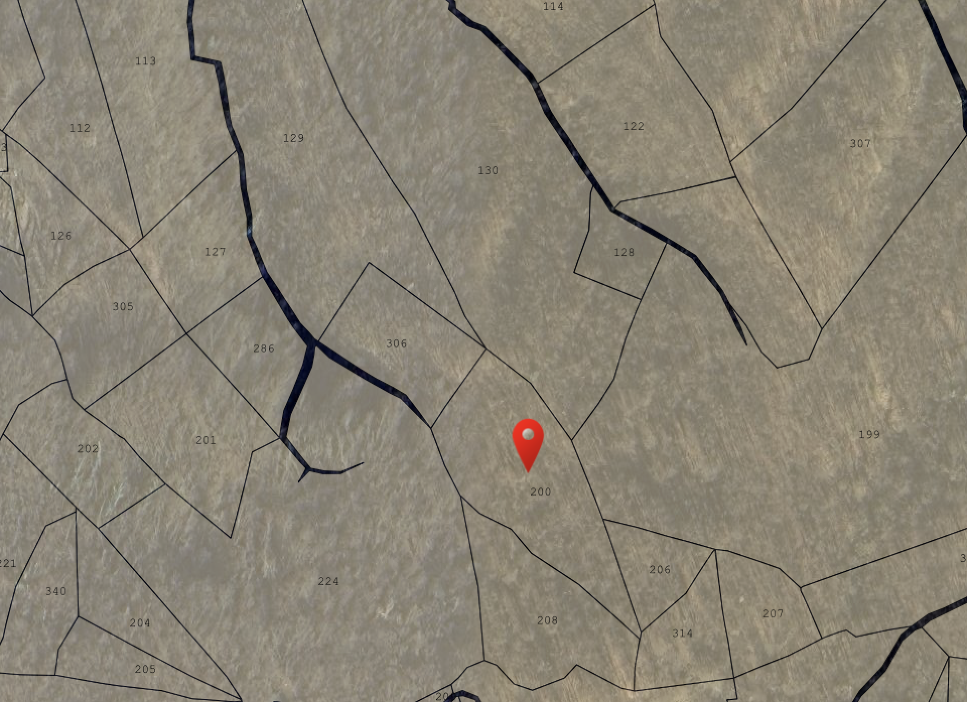
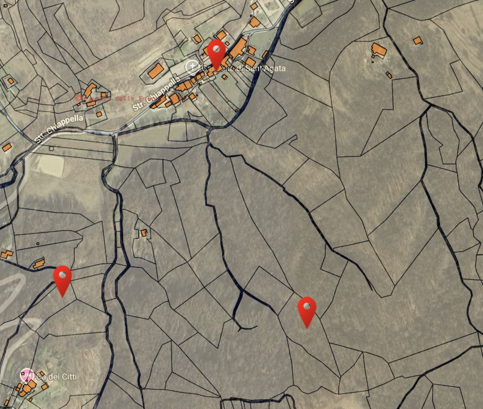
- Location: Google Maps | Coordinates: 44.399902, 8.255036
- Land Registry: Foglio 46, Particella 200 (Total Area: 4,410 m²)
Description and Potential Use
This property consists of a single large plot (Particella 200, 4,410 m²), which is steep and heavily wooded. It is located at the source of a stream—the very one that flows into the larger stream near our house. However, due to the direction of the current, water from this source flows away from our main property.
- Potential Uses:
- 5G Antenna Installation: The high ground could be interesting for installing a 5G internet antenna to get a faster connection in the valley. However, it’s unclear if the signal is actually better there; this needs to be tested.
- Firewood Harvesting: The land can be used as a source of firewood. Transporting the wood would be a challenge as there is no vehicle access. It could potentially be moved by hand or by using the stream during high water for smaller logs. Once the wood reaches the main stream, it would flow away from the house but could be collected further down along Str. Chiappella and transported the final distance with a vehicle.
- Agricultural Use: The northwest-facing slope provides non-optimal sun exposure, making it unsuitable for most agricultural purposes.
Legal Strategy and Surrounding Plots
This area is promising for applying Usucapione (Adverse Possession) due to the low number of nearby buildings.
- Key Plots of Interest:
- 224 & 199: Large adjacent plots that could serve as a bordering forest for additional firewood or for as-yet-unknown Supplementary Projects.
- 130, 306 & 129: Strips of land that follow the stream down towards the valley.
- 211 & 212: An interesting cleared spot located slightly higher up. The reason for the clearing is unknown, but it could be a potential camping area.
Risks and Verifications
- Identified Risks: The steepness of the terrain and the presence of water sources mean that hydrological and landslide risks must be verified.
- Verification Status: I have not yet personally visited the site.
Abstract
Questo documento descrive i Terreni alla Fonte, un ampio appezzamento scosceso e boschivo situato alla sorgente di un torrente. Con una superficie di oltre 4.000 m², il suo potenziale principale risiede nella silvicoltura (legna da ardere) e in installazioni strategiche (antenna 5G), piuttosto che nell’agricoltura.
- Posizione: Google Maps | Coordinate: 44.399902, 8.255036
- Dati Catastali: Foglio 46, Particella 200 (Superficie Totale: 4.410 m²)
Descrizione e Potenziale d’Uso
La proprietà consiste in un unico grande lotto (Particella 200, 4.410 m²), scosceso e molto boscoso. È situato alla fonte di un torrente, proprio quello che sfocia nel torrente più vicino a casa nostra. Tuttavia, il verso della corrente non permette un flusso d’acqua da questo terreno fino a casa, poiché il torrente principale scorre nella direzione opposta.
- Usi Potenziali:
- Installazione Antenna 5G: La posizione elevata potrebbe essere interessante per installare un’antenna internet 5G per ottenere una connessione più veloce in paese. Non è però chiaro se la ricezione lì sia effettivamente migliore; è una cosa da sperimentare.
- Legna da Ardere: Il terreno può essere usato come fonte di legna. Il trasporto sarebbe una sfida, data l’assenza di accesso carrabile. Si potrebbe pensare di portarla a mano o usare il torrente in piena per tronchi di modeste dimensioni. Una volta raggiunto il torrente principale, la legna andrebbe nella direzione opposta alla casa, ma potrebbe essere raccolta più a valle lungo Str. Chiappella e trasportata con un mezzo privato per l’ultimo tratto.
- Uso Agricolo: L’esposizione a nord-ovest del versante non è ottimale per l’esposizione solare, rendendo il terreno non idoneo per la maggior parte degli scopi agricoli.
Strategia Legale e Terreni Circostanti
Questa zona è promettente per l’applicazione dell’Usucapione, dato il numero molto ridotto di fabbricati vicini.
- Lotti di Interesse per Usucapione:
- 224 & 199: Grandi lotti vicini che potrebbero essere usati come area boschiva limitrofa per ulteriore legna o per altri progetti supplementari ancora non definiti.
- 130, 306 & 129: Fasce di terreno che seguono il torrente verso la valle.
- 211 & 212: Uno spiazzo privo di alberi situato poco più in alto. La ragione non è chiara, ma potrebbe essere un’interessante area per il campeggio.
Rischi e Verifiche
- Rischi Identificati: La pendenza del terreno e la presenza di rigagnoli d’acqua impongono di verificare i rischi idrogeologici e di frana.
- Stato Verifiche: Non sono ancora stato personalmente sul terreno.